Education for all people
Close
Menu

Navigation

  • 1 Year
  • 5th Year
  • Literatures
  • Portuguese Language
  • English
    • Russian
    • English
    • Arabic
    • Bulgarian
    • Croatian
    • Czech
    • Danish
    • Dutch
    • Estonian
    • Finnish
    • French
    • Georgian
    • German
    • Greek
    • Hebrew
    • Hindi
    • Hungarian
    • Indonesian
    • Italian
    • Japanese
    • Korean
    • Latvian
    • Lithuanian
    • Norwegian
    • Polish
    • Romanian
    • Serbian
    • Slovak
    • Slovenian
    • Spanish
    • Swedish
    • Thai
    • Turkish
    • Ukrainian
    • Persian
Close

Geography Activities 3rd year of Elementary School

We have prepared a list with several suggestions for 3 year Geography Activities of Elementary School ready to print and apply in the classroom or as a homework assignment.

Subjects that can be worked on in the second year of elementary school:

the municipality

  • what is municipality
  • Municipal administration
  • Every municipality has a history
  • City landscapes

geographical orientation

  • Orienting yourself in the municipality: cardinal points
  • Orienting yourself in the city: side points
  • Looking at the city from different points of view
  • Representing the municipality

Industry, commerce and services

  • industrial activity
  • Transforming the raw material
  • Commerce and services
  • Relations between countryside and city

Water in the municipality

  • the rivers
  • The use of rivers
  • The water we consume
  • It is necessary to take care of the rivers
  • Fertilizers and pesticides contaminate rivers

Ambiental degradation

  • Environmental problems in the field
  • Environmental problems in the city

Among others..

Index

  • 3 year Geography Assessment
  • 3 year Geography Activities – To Print and Copy
  • Geography Activity for the 3rd year – Map
  • Geography Activities 3rd year: The means of transport and the way to school
  • The ambient sounds and music
  • 3 Year Geography Activities for Home (Tasks)

3 year Geography Assessment

The objective of this Geography evaluation is to verify if the student has awakened his eyes to the transformations in the environment, in accordance with the concepts worked on in the first two months.

The student should be able to recognize the ways in which man intervenes in nature, as well as the ways in which natural phenomena interfere in the landscape.

 See also: Map of Brazil to color.

3 year Geography Activities – To Print and Copy

To work with your third year students of elementary School, we have gathered several suggestions with educational activities, check out:

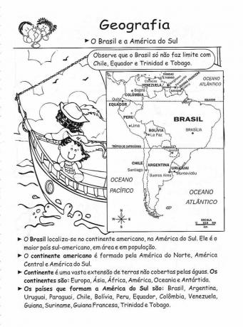
Brazil and South America: Please note that Brazil only does not border Chile, Ecuador and Trinidad and Tobago

3rd Year Geography Activities - Print

Earth: The world we live in – It is part of our solar system.

3rd Year Geography Activities - Print

Replace the drawings with words and rewrite the sentences. Then paint the map.

3rd Year Geography Activities - Print

The Relief:

The Earth's surface is not the same throughout its entirety. Some places are flatter and others more rugged also have high regions and low regions.

3rd Year Geography Activities - Print - Relief

Work in Industry.

3rd Year Geography Activities - Print

Public services: Municipalities pay fees for:

The Earth: is a round-shaped plant, slightly flattened at the poles. There are two poles: the North Pole and the South Pole.

3rd Year Geography Activities - Print - The Earth

The means of transport allow people to move from one place to another. They can be land, air and sea.

3rd Year Geography Activities - Print - Means of Transport

Bimonthly Geography Assessment 3 year

  • Bimonthly Geography Assessment 3 year - To print - Sheet 01
  • Bimonthly Geography Assessment 3 year - To print - Sheet 02
  • Bimonthly Geography Assessment 3 year - To print - Sheet 03

____

Geography Activity for the 3rd year – Map

Europe map

It is Geography Activity 3 year educational aims to allow the student to perceive and identify different types of maps.

In order for your students to understand what you want to represent on each map, and to what extent they can distort or hide real data.

Material to be used

  • A modern political map
  • an old map
  • A satellite photo

Procedure

First step

The teacher should first present the modern political map, drawing students' attention to the following points:

  • What concerns the internal divisions.
  • If there is distortion in the shape of countries.
  • What are the ways to represent spherical surfaces on flat surfaces.
  • What are the uses of this map? Who is it for?

Second stage

  • The second map to be displayed will be the old map. This type of map usually reveals very strong elements of the imagery of the time it was created.
  • Value the following points at the time of the presentation:
  • What did the person who created this map want to represent?
  • What are the uses of this map? Who is it for?
  • What types of paths are shown on the map? Sea routes, rivers?
  • How big is one continent relative to another? Is there an overvaluation of some region while another is neglected or unknown?
  • What other curious elements does the map have?

third step

  • Present the satellite photo and ask students to compare it with the reality shown on the map.
  • Ask them to try to identify if the human presence is visible in the photo.
  • Are there points of light? What are these points? Where else can human presence be identified?
  • Is it possible to identify polluted areas and green areas?
  • What kind of landscapes can you identify?
  • Can even a photo be considered a representation of reality?
  • Is it possible to see the territorial borders and boundaries included in the political map? Why not?

Fourth step (optional)

  • The maps presented can also serve to lead an interdisciplinary activity with some mathematical notions such as:
  • Projection
  • Scale
  • Proportion, etc.

___

Geography Activities 3rd year: The means of transport and the way to school

The purpose of this 3 year geography activity it is to allow the student to know and identify the different types of means of transport, from the oldest to the most modern.

This activity will also allow the student to get to know school realities from other cultures. The subject of History can also be worked on.

Material used

Film: Children of Heaven, by Majid Majidi, Iran, 1997

This film tells the story of a boy who loses his sister's only shoes, and is forced to share his only pair with her so that they can go to school properly. Many curious situations are generated from this situation, as the boy studies in the morning and his sister in the afternoon. So he has to run every day between school and his house to deliver the shoes to his sister on time. In this case, the means of transport used are the shoes themselves. This film will allow the student to realize that, although the route to school is the same every day, many things can change from one day to another along this route. It will better develop your perception of space and time, geography and history.

Procedures

First step

Film screening for students

Second stage

After the movie, ask students to provide critiques and comments about the movie they watched. Encourage observations.

After listening to the students' general comments about the film, the teacher will be able to instigate the following reflections:

  • What were the means of transport used by the people in the film?
  • Can't driving by car take longer than walking?
  • What are the advantages and discoveries that the character in the film found by walking?

third step

The teacher can encourage their students to create a comic book about a day on the way home to school. It can be a true story or an imaginary one.

fourth step

The teacher should encourage the comparison between the stories produced by students who do the same route to school, noting differences and similarities of looking at the same neighborhood or environment.

___

The ambient sounds and music

The purpose of this 3 year geography activities it is to allow the student to perceive and identify the relationship between man and the environment based on music.

Material to be used

  • Sounds from different environments: urban, rural, street, house etc. These sounds can be collected with a handheld recorder, or collected on the internet.
  • Several songs of musical styles related to the environments represented in the collected sounds.

Procedures

First step

  • The teacher should show the different types of sounds collected and students should be able to reconstruct, with their imagination, their original environments.
  • Students should be encouraged to recognize the origin of all the small sounds that make up each environment.

Second stage

  • The teacher should encourage the student to compare the sound of different environments.
  • Which sound is faster? Which is slower?
  • What is the simplest sound? Which environment contains the most different sounds?
  • Which environment reveals the human presence the most?
  • Which environment has the presence of the most preserved nature?

third step

Based on these observations, the teacher should present excerpts from the music related to the environments previously presented.

Examples:

  • Forest Sounds - Indigenous Music
  • Urban sounds – rock, electronic music.
  • Rural environments – folk music, regional music, etc.

fourth step

  • Students must relate the songs to the respective environments that produced them.

fifth step 

  • The teacher will be able to introduce sounds from a new environment so that students can imagine what kind of music will be produced in such an environment.
  • The teacher will be able to encourage students to produce the specific musicality for the type of environment presented.
  • The opposite can also be done: the teacher can present a musical style and ask students to imagine what kind of environment that music reflects.

___

3 Year Geography Activities for Home (Tasks)

1) For coexistence in society, it is important to have norms and common feelings among people, such as:

RESPECT KINDNESS
FRIENDSHIP COMPANIONSHIP

2) Make a sentence with each word above.

___

3) Draw a natural landscape, without transformations caused by nature or by man (asphalt, buildings, poles).

Are we going to transform this landscape?

4) Now draw the same landscape and complete it with man-made (cultural) elements.

3) Draw or paste a landscape that has been modified by natural factors. It could be some report of flooding caused by rain, for example.

Subscribe to our email list and receive interesting information and updates in your email inbox

Thanks for signing up.

Treasury Educa+ enables funding for higher education
on Aug 04, 2023
Mealybugs: Learn how to get rid of this pest!
on Aug 02, 2023
Incidence of the avian flu virus makes countries declare a state of emergency
on Aug 02, 2023
1 Year5th YearLiteraturesPortuguese LanguageMind Map FungiMind Map ProteinsMathMaternal IiMatterEnvironmentLabor MarketMythology6 YearMoldsChristmasNewsNews EnemNumericalWords With CParlendasSharing AfricaThinkersLesson Plans6th YearPoliticsPortugueseRecent Posts Previous PostsSpringFirst World WarMain
  • 1 Year
  • 5th Year
  • Literatures
  • Portuguese Language
  • Mind Map Fungi
  • Mind Map Proteins
  • Math
  • Maternal Ii
  • Matter
  • Environment
  • Labor Market
  • Mythology
  • 6 Year
  • Molds
  • Christmas
  • News
  • News Enem
  • Numerical
Privacy
© Copyright Education for all people 2025