We have gathered in this article several suggestions for Geography Activities to work with your students in classroom and homework.
excellent activities to work with students from Elementary School.
Index
several Activities to print from geography with landscapes, means of transport, and means of communication that must be applied in the 1st year of elementary school and also in the 2nd year.
Look at the position charts and paint them.
correctly relate
Municipalities pay fees for:
Paint the flag of Brazil with the corresponding colors.
Look at the images:
Name the parts of the plant that appear in the illustration and draw those that don't
Circle living things, mark non-living things with an x.
Find the parts of the plants in the word search, and write them on the rectangle.
Searching the table below for names of living beings and non-living beings. Write down the names.
See others 1 year geography activities.
Various educational activities ready to print and apply:
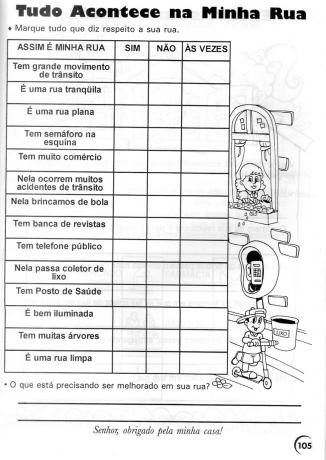
Check YES or NO by coloring the comics:

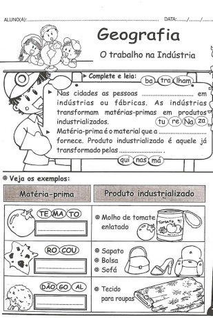
Work in industry;
Public services:

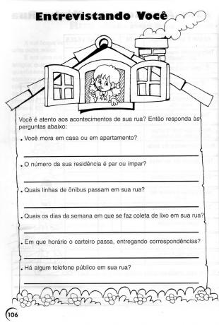
Interviewing you: Are you responsive to the happenings on your street? So, answer the questions:

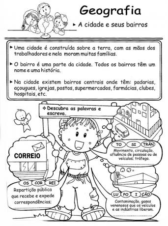
The city and its neighborhoods
List correctly:

See others 2 year geography activities.
To work with your third year students of elementary School, we have gathered several suggestions with educational activities, check out:
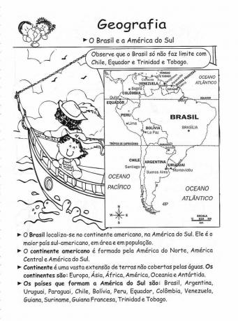
Brazil and South America: Please note that Brazil only does not border Chile, Ecuador and Trinidad and Tobago
Earth: The world we live in – It is part of our solar system.

Replace the pictures with words and rewrite the sentences. Then paint the map.

The Relief:
The Earth's surface is not the same throughout its entire extent. Some places are flatter and others more rugged also have high regions and low regions.

Work in Industry.

Public services: Municipalities pay fees for:

The Earth: is a round-shaped plant, slightly flattened at the poles. There are two poles: the North Pole and the South Pole.

The means of transport allow people to move from one place to another. They can be land, air and sea.

Check out this super geography activity to work with your 4th grade elementary school class. Material available for free download in PDF.
To download the material, check the following link:
Wonderful activity whose main objective is to enable students to discover some of the regions of Brazil where Afro-Brazilian cultural manifestations are present and preserved.
See more at: Geography activities for the 3rd year.
If you are a parent or teacher and are looking for attractive activities geography for 4 year classes is in the right place.
Here's a list of some ready-to-print suggestions.
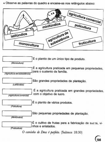
Note the words on the board and fit into the rectangles below:
Brazilian Regions – Brazil is organizing by regions. Create a legend for each region and paint the map.

See others 4 year geography activities.
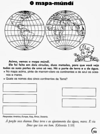
The world map:
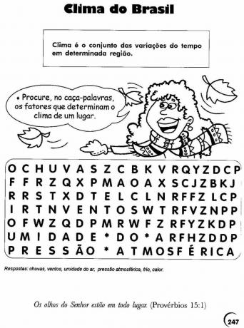
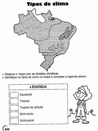
Climate in Brazil: Climate is the set of weather variations in a given region.
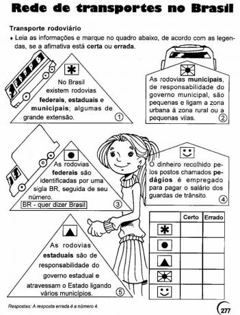
Transport network in Brazil:
Read the information and check the box below, according to the captions, if the statement is right or wrong.
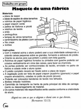
Model of a Factory – Group work.
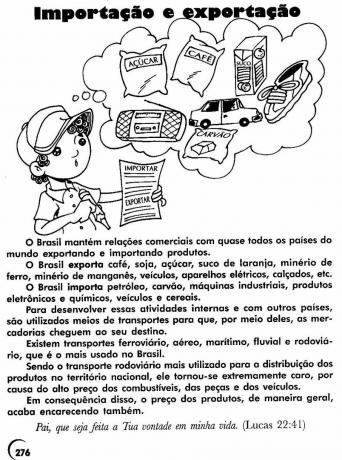
Import and export.
Agriculture

Weather Types: Look at the map with weather divisions. Identify weather types on the map and complete the legend:
Researching: Research labor rights by taking into account the items below and note the information found in your notebook.
Cruza América – The American continent is formed by the three Americas: North, Central and South America;
Fill in the crossword as indicated.

See more: Geography Activities for the 5th year.
The population distribution in the Brazilian territory occurs irregularly, with some regions with many inhabitants and others with a small population. The least populated Brazilian region, with a demographic density around 4 inhab./km² is:
a) Northeast.
b) Southeast.
c) South.
d) North.
e) Midwest.
Observing the Sun, the human being realized that this star appears (at dawn) and disappears (at dusk) in approximately the same directions every day. Based on this observation, a set of orientation points, called cardinal points, was determined. Are they:
a) East, West, North and South.
b) northeast, southeast, south and southwest.
c) North, Northeast, Midwest, South.
d) Latitude, longitude, hemispheres and equator.
e) Amazon, northeast, north and south.
The American continent shows great climatic variation in its extension, with vegetation characteristics also very varied. This is due to natural factors such as:
a) soil diversity.
b) large territorial extension.
c) altitude diversity.
d) small strips of land.
A country can be considered tropical when:
a) is located between the tropics of Cancer, Capricorn and the Equator.
b) are located in the Arctic region.
c) is located between the tropic of Cancer and the Arctic polar circle.
d) is located at the north pole.
Check the correct alternative - Brazil is located in the hemispheres:
a) North and West.
b) Mostly in the southern hemisphere and west of Greenwich.
c) In the southern hemisphere and east of Ecuador.
d) In east and north of Japan.
Miscegenation brought a great diversity of cultural traits in the formation of the Brazilian population.
Analyze the questions related to the formation of the Brazilian population, then check (V) for the correct alternatives and (F) for the false ones.
( ) This diversity shows cultural characteristics, such as language, religion, music, habits
food, skin color, hair color, height, etc.
( ) From the Portuguese we inherit our official language.
( ) In the Portuguese language spoken in Brazil, there are many words of indigenous and African origin.
( ) Indigenous culture and society do not change over time.
( ) Speaking Portuguese, wearing clothes and using new technologies such as cameras, computers,
cell phones, etc., indigenous people lose their identity, that is, they are no longer indigenous.
The official regionalization of Brazil was made by the IBGE (Brazilian Institute of Geography and Statistics) and has been in force since 1988 and since that date our territory is divided into:
a) 5 regions, 23 states and 1 federal district
b) 4 regions, 25 states and 1 federal district.
c) 5 regions, 26 states and 1 federal district.
d) 5 regions, 27 states and 1 federal district.
Connect the figures of the people to the figures of the corresponding houses:
Federative Republic of Brazil
Teacher starts the class with the class organized in a conversation circle.
THE landscape can be defined as everything that is in front of our eyes, that is, everything that the human senses can reach, so we can say that landscapes are part of our daily life, as this will always be present in our lives.
On the way you go to school, you will be able to see the difference between the landscapes, whether it is a dense forest that is it is possible to see that there is no transformation by man and also the streets, houses and buildings, which are the result of transformation human.
Look at the images and paint each one of them according to how you imagine the environment of each one of them:
Circulate what is unnatural in this landscape, that is, it was built by people. Then paint only the natural elements.
To make it easier for you to print, we've decided to provide a small booklet with some suggestions for educational geography activities about landscapes to print.

An activity for students to be able to differentiate between disasters that were caused by the human “help” and those that are in fact natural disasters, where society has no control over they. A disaster caused by human action that you teacher can use as an example is the rupture of the mistletoe dam, which left many dead.
Suggest that students get together in pairs or groups and select two of these disasters, one natural and one man-made, and draw or paste pictures of them.
After that, discuss the topic in the classroom, which can be in a round of conversation or work presentation.
___
Subscribe to our email list and receive interesting information and updates in your email inbox
Thanks for signing up.