Education for all people
Close
Menu

Navigation

  • 1 Year
  • 5th Year
  • Literatures
  • Portuguese Language
  • English
    • Russian
    • English
    • Arabic
    • Bulgarian
    • Croatian
    • Czech
    • Danish
    • Dutch
    • Estonian
    • Finnish
    • French
    • Georgian
    • German
    • Greek
    • Hebrew
    • Hindi
    • Hungarian
    • Indonesian
    • Italian
    • Japanese
    • Korean
    • Latvian
    • Lithuanian
    • Norwegian
    • Polish
    • Romanian
    • Serbian
    • Slovak
    • Slovenian
    • Spanish
    • Swedish
    • Thai
    • Turkish
    • Ukrainian
    • Persian
Close

Asia map: physical, political, climates and regional division

Meet in this post the Asia map and geographic data for the continent.

Asia is the largest of the continents, both in area and population. It covers one-third of the solid parts of the Earth's surface and is responsible for home to nearly three-fifths of the world's population.

With a territorial extension of approximately 43,810,852 km² and with 50 countries across the continent, the Map of Asia is surrounded by the following oceans and seas:

  • Arctic Glacial Ocean (north); Pacific Ocean (South and Southwest coast); Indian Ocean (East Coast).

Index

  • Asia map
  • Asia countries
  • Asia political map
  • Asia Map – Regional Division
  • Asia Physics Map
  • Main features of Asia
  • Asia Map – Climates
  • Map of Asia to color and print

Asia map

Asia map

Asia countries

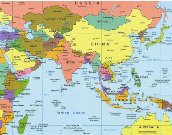
Asia is very large and is divided into (Central Asia, North Asia, East Asia, South Asia, West Asia.

Central Asia

  • Kazakhstan (Astana);
  • Kyrgyzstan (Bishkek);
  • Tajikistan (Duchambe);
  • Turkmenistan (Asgabat);
  • Uzbekistan (Tashkent).

north asia

  • Russia (Moscow)

Eastern Asia

  • China (Beijing);
  • Japan (Tokyo);
  • South Korea (Seoul);
  • North Korea (Pyongyang);
  • Taiwan (Taipei);
  • Mongolia (Ulan Bator).

south asia

  • Bangladesh (Dhaka);
  • Bhutan (Thimphu);
  • India (New Dheli);
  • Maldives (Malé);
  • Nepal (Kathmandu);
  • Pakistan (Islamabad);
  • Sri Lanka (Sri Jayewardenepura Kotte / Colombo).

Southeast Asia

  • Brunei (Bandar Seri Begawan);
  • Cambodia (Phnom Penh);
  • Philippines (Manila);
  • Indonesia (Jakarta);
  • Laos (Vientiane);
  • Malaysia (Putrajava / Kuala Lumpur);
  • Myanmar (Naypyidaw / Yangon);
  • Singapore (City of Singapore);
  • Thailand (Bangkok);
  • East Timor (Dili);
  • Vietnam (Hanoi).

West Asia

  • Afghanistan (Kabul);
  • Saudi Arabia (Riyadh);
  • Armenia (Erevan);
  • Azerbaijan (Baku);
  • Bahrain (Manama);
  • Cyprus (Nicosia);
  • United Arab Emirates (Abu Dhabi);
  • Georgia (Tbilisi);
  • Yemen (Sanana / Aden);
  • Iraq (Baghdad);
  • Iran (Tehran);
  • Israel (Jerusalem);
  • Jordan (Amman);
  • Kuwait (Kuwait City);
  • Lebanon (Beirut);
  • Oman (Muscat);
  • Palestine (Eastern Jerusalem / Ramallah);
  • Qatar (Doha);
  • Syria (Damascus);
  • Turkey (Ankara).

Asia political map

Model 01:

Asia political map

Models 02:

Asia political map

Asia map – Regional Division

 Asia Map - Regional Division

Asia Physics Map

Main features of Asia

Climates:

  • POLAR - TWO SEASONS, SHORT SUMMER WITH TEMP. BELOW 15° AND RIGOROUS WINTERS WITH SNOW FALL AND TEMP. BELOW 20°
  • COLD AND COLD MOUNTAIN
  • SEASONED - FEATURES THE 4 WELL DEFINED SEASONS
  • MEDITERRANEAN - HOT, DRY SUMMERS AND WARM LIGHTER WINTERS
  • SEMI-ARID
  • DESERT
  • SUBTROPICAL
  • TROPICAL
  • EQUATORIAL

NOTE: IN THE SUBTROPICAL, TROPICAL AND EQUATORIAL REGIONS, THE MONSOON CLIMATE APPEARS

Limits:

  • TO THE NORTH - ARCTIC GLACIAL OCEAN
  • TO THE SOUTH – INDIAN OCEAN
  • WEST - URAL MOUNTAINS, CASPIAN SEA, CAUCASUS, BLACK SEA, SEA
  • MEDITERRANEAN AND RED SEA.
  • EAST - PACIFIC OCEAN

Relief:

  • ANCIENT MOUNTAINS - URAL MOUNTAINS AND KOLYMA
  • RECENT MOUNTAINS - HIMALAYA WHERE THE HIGHEST ELEVATIONS ON THE PLANET ARE FOUND - EVEREST PEAK (8,848 M ALTITUDE) AND K-2
  • PLATEAU – ANATÓLIA (TURKEY), SIBERIA (RUSSIA), PAMIR (TIBET), DECAN (INDIA) AND THE PLATEAU OF ARABIA
  • PLAINS - MESOPOTAMIA (IRAQ), INDO-GANGÉTICA (PAKISTAN AND INDIA), CHINA AND INDOCHINA
  • DEPRESSIONS - DEAD SEA, CASPIAN SEA AND ARAL

Hydrography and coast

  • OCEAN – PACIFIC, INDIAN AND ARCTIC
  • SEAS – BLACK, MARMAR, MEDITERRANEAN, AEGEAN, RED, RED AND YELLOW (CHINA), AND THE CLOSED SEAS CASPIAN, DEAD AND ARAL
  • GULFS – ACABAH, ADEN, PERSIAN, OMAN, CANE ETC.
  • NARROWS – BOSPHOR, DARDANELS, BAB-ELMONDEB, SUEZ, ORMUZ, BERING
  • PENINSULAS – ASIA MINOR (TURKEY), SINAI (EGYPT), ARABICA (ARABIA ETC.), DECAN (INDIA), INDOCHINA, MALAYA, KOREA AND KAMTCHAKA (RUSSIA)

Main rivers:

  • OBI, IENISSEI AND LENA – RUSSIA TO THE ARCTIC GLACIAL SEA (FREEZE IN INV.)
  • HOANG HO (YELLOW), YANG TSE KIANG (BLUE), SINKIANG (OF PEARLS) – CHINA
  • MECONG – INDOCHINE PENINSULA
  • GANGES, INDO AND BRAMAPUTRA – INDO-GANGÉTICA PLAIN
  • EUPHRATES AND TIGER – MESOPOTHAMIAN PLAIN
  • JORDAN – IERAEL AND JORDAN

Asia map – Climates

Asia Map - Climates

Asia is located east of the Greenwich meridian, that is, in the Eastern Hemisphere. Of all the existing continents, Asia is the largest, with an area of ​​44 million square kilometers.

The boundary limits that exist on the Asian continent are: to the north, the Arctic Glacial Ocean; to the south, Indian Ocean; to the east, the Pacific Ocean; to the west, the Red Sea, which separates it from the African continent, the Mediterranean Sea and the Ural Mountains, which separates it from Europe.

The largest continent in the world, home to five of the ten most populous countries on the planet, are they:

  • China (1.3 billion inhabitants),
  • India (1.1 billion),
  • Indonesia (234 million),
  • Pakistan (169 million),
  • Bangladesh (150 million),
  • Japan (127 million).

The product of the sum of all the countries mentioned represents approximately 60% of the total population of the planet.

Map of Asia to color and print

To color is a great way to work maps with students in the classroom or homework, here are some suggestions to print for free:

We also recommend:

  • Europe map
  • America Map
  • Africa Map

Subscribe to our email list and receive interesting information and updates in your email inbox

Thanks for signing up.

Project Professions Elementary School and Early Childhood Education
on Jul 22, 2021
Industrial Revolution - Education and Transformation
on Jul 22, 2021
Water Day Activities
on Jul 22, 2021
1 Year5th YearLiteraturesPortuguese LanguageMind Map FungiMind Map ProteinsMathMaternal IiMatterEnvironmentLabor MarketMythology6 YearMoldsChristmasNewsNews EnemNumericalWords With CParlendasSharing AfricaThinkersLesson Plans6th YearPoliticsPortugueseRecent Posts Previous PostsSpringFirst World WarMain
  • 1 Year
  • 5th Year
  • Literatures
  • Portuguese Language
  • Mind Map Fungi
  • Mind Map Proteins
  • Math
  • Maternal Ii
  • Matter
  • Environment
  • Labor Market
  • Mythology
  • 6 Year
  • Molds
  • Christmas
  • News
  • News Enem
  • Numerical
Privacy
© Copyright Education for all people 2025